Boundary Advice
Research & Analysis
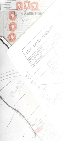
A landowner may become unnecessarily concerned about his boundaries due to misinterpreting the information on the Title Register and Title Plan that are available from the Land Registry for every registered property in England and Wales. The Title Plan shows the ‘general boundary’ position it does not determine the exact line of a boundary. The accuracy tolerances of the Ordnance Survey map upon which the plan is based, combined with the inaccuracy of scaling distances off the plan mean that what you actually measure on the ground will not match that scale thus sometimes leading to confusion.
As a Chartered Land Surveyor, I am able to explain the limitations of the Title Plan and interpret the information from the Title Register to help give you a better understanding of the general boundaries to your property. If required, I can also complete a measured survey of your property to produce a large scale plan indicating the precise position of the existing boundaries and other relevant features such as buildings, driveways and any redundant boundary features. In addition to surveying the existing configuration of your land, I can also research and analyse available historical evidence such as the Deeds and conveyance plan, the Title Register, historical aerial photography and maps to assess the original boundary position or its intended position.
The comparison of the present-day boundary to the original will form the basis of a professional report that is unbiased in its opinion thus enabling the client to make a rational informed decision on how to proceed. Ideally, because the report is an independent professional assessment on the boundary alignment, adjoining owners can use it as a catalyst to amicably resolving a dispute that might otherwise have to be resolved by the courts. In such circumstances it is not unknown for the boundary surveyor to act as a mediator, brokering an agreement between the parties.

Land Surveys
Professional Land Surveys carried out by a highly experienced professional, producing high-quality plans accepted by the Land Registry.

Boundary Disputes
Whether it is recognising undefined boundaries or helping to resolve boundary disputes between multiple parties, trust our expertise in every element of property boundaries.

Expert Witness
We can help if you need an Expert Witness in regards to boundaries or Land Surveying cases.

Concerned about your boundary?
We offer initial consultancy and can conduct an accurate site survey and investigation to produce a large scale plan suitable for inclusion in an expert report.

Do you have a specific survey requirement?
We can provide surveying solutions for your topographic, hydrographic, engineering, measured building and GPS requirements.